< < VS09.3 : VS10.1 : VS10.2 > >
VS10.1: Traditional Restricted Lane Warning Implementation
Dynamic message signs or other infrastructure-based signage is used to provide restricted lane information directly to the driver.
Relevant Regions: Australia, Canada, European Union, and United States
- Enterprise
- Functional
- Physical
- Goals and Objectives
- Needs and Requirements
- Sources
- Security
- Standards
- System Requirements
Enterprise
Development Stage Roles and Relationships
Installation Stage Roles and Relationships
Operations and Maintenance Stage Roles and Relationships
(hide)
| Source | Destination | Role/Relationship |
|---|---|---|
| Basic Vehicle Manager | Driver | System Usage Agreement |
| Basic Vehicle Owner | Driver | Application Usage Agreement |
| Basic Vehicle Owner | Driver | Vehicle Operating Agreement |
| Basic Vehicle Owner | Vehicle Owner | Expectation of Data Provision |
| ITS Roadway Equipment Maintainer | ITS Roadway Equipment | Maintains |
| ITS Roadway Equipment Manager | ITS Roadway Equipment | Manages |
| ITS Roadway Equipment Manager | Maint and Constr Field Personnel | System Usage Agreement |
| ITS Roadway Equipment Owner | ITS Roadway Equipment Maintainer | System Maintenance Agreement |
| ITS Roadway Equipment Owner | ITS Roadway Equipment Manager | Operations Agreement |
| ITS Roadway Equipment Owner | Traffic Management Center Maintainer | Maintenance Data Exchange Agreement |
| ITS Roadway Equipment Owner | Traffic Management Center Owner | Information Exchange Agreement |
| ITS Roadway Equipment Owner | Traffic Management Center User | Service Usage Agreement |
| ITS Roadway Equipment Owner | Traffic Operations Personnel | Application Usage Agreement |
| ITS Roadway Equipment Supplier | ITS Roadway Equipment Owner | Warranty |
| Maint and Constr Field Personnel | ITS Roadway Equipment | Operates |
| Traffic Management Center Maintainer | Traffic Management Center | Maintains |
| Traffic Management Center Manager | Traffic Management Center | Manages |
| Traffic Management Center Manager | Traffic Operations Personnel | System Usage Agreement |
| Traffic Management Center Owner | ITS Roadway Equipment Maintainer | Maintenance Data Exchange Agreement |
| Traffic Management Center Owner | ITS Roadway Equipment Owner | Information Exchange Agreement |
| Traffic Management Center Owner | ITS Roadway Equipment User | Service Usage Agreement |
| Traffic Management Center Owner | Maint and Constr Field Personnel | Application Usage Agreement |
| Traffic Management Center Owner | Traffic Management Center Maintainer | System Maintenance Agreement |
| Traffic Management Center Owner | Traffic Management Center Manager | Operations Agreement |
| Traffic Management Center Supplier | Traffic Management Center Owner | Warranty |
| Traffic Operations Personnel | Traffic Management Center | Operates |
| Vehicle Manager | Driver | System Usage Agreement |
Functional
This service package includes the following Functional View PSpecs:
Physical
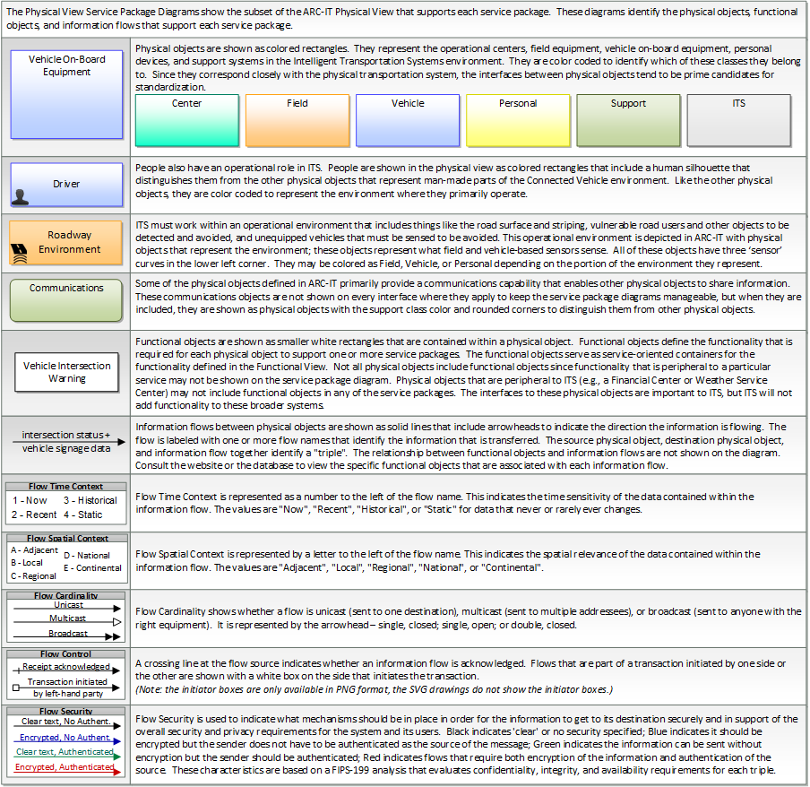
The physical diagram can be viewed in SVG or PNG format and the current format is SVG.SVG Diagram
PNG Diagram
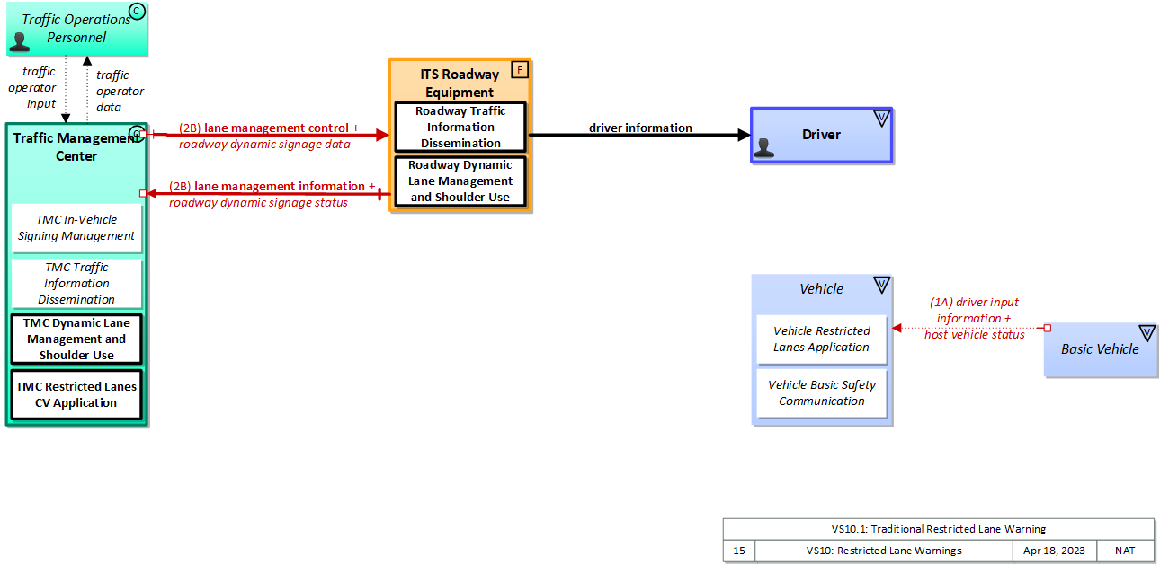
Includes Physical Objects:
| Physical Object | Class | Description |
|---|---|---|
| Driver | Vehicle | The 'Driver' represents the person that operates a vehicle on the roadway. Included are operators of private, transit, commercial, and emergency vehicles where the interactions are not particular to the type of vehicle (e.g., interactions supporting vehicle safety applications). The Driver originates driver requests and receives driver information that reflects the interactions which might be useful to all drivers, regardless of vehicle classification. Information and interactions which are unique to drivers of a specific vehicle type (e.g., fleet interactions with transit, commercial, or emergency vehicle drivers) are covered by separate objects. |
| ITS Roadway Equipment | Field | 'ITS Roadway Equipment' represents the ITS equipment that is distributed on and along the roadway that monitors and controls traffic and monitors and manages the roadway. This physical object includes traffic detectors, environmental sensors, traffic signals, highway advisory radios, dynamic message signs, CCTV cameras and video image processing systems, grade crossing warning systems, and ramp metering systems. Lane management systems and barrier systems that control access to transportation infrastructure such as roadways, bridges and tunnels are also included. This object also provides environmental monitoring including sensors that measure road conditions, surface weather, and vehicle emissions. Work zone systems including work zone surveillance, traffic control, driver warning, and work crew safety systems are also included. |
| Traffic Management Center | Center | The 'Traffic Management Center' monitors and controls traffic and the road network. It represents centers that manage a broad range of transportation facilities including freeway systems, rural and suburban highway systems, and urban and suburban traffic control systems. It communicates with ITS Roadway Equipment and Connected Vehicle Roadside Equipment (RSE) to monitor and manage traffic flow and monitor the condition of the roadway, surrounding environmental conditions, and field equipment status. It manages traffic and transportation resources to support allied agencies in responding to, and recovering from, incidents ranging from minor traffic incidents through major disasters. |
| Traffic Operations Personnel | Center | 'Traffic Operations Personnel' represents the people that operate a traffic management center. These personnel interact with traffic control systems, traffic surveillance systems, incident management systems, work zone management systems, and travel demand management systems. They provide operator data and command inputs to direct system operations to varying degrees depending on the type of system and the deployment scenario. |
Includes Functional Objects:
| Functional Object | Description | Physical Object |
|---|---|---|
| Roadway Dynamic Lane Management and Shoulder Use | 'Roadway Dynamic Lane Management and Shoulder Use' includes the field equipment, physical overhead lane signs and associated control electronics that are used to manage and control specific lanes and/or the shoulders. This equipment can be centrally controlled by a Traffic Management Center or it can be autonomous and monitor traffic conditions and demand along the roadway and determine how to change the lane controls to respond to current conditions. Lane controls can be used to change the lane configuration of the roadway, reconfigure intersections and/or interchanges, allow use of shoulders as temporary travel lanes, designate lanes for use by special vehicles only, such as buses, high occupancy vehicles (HOVs), vehicles attending a special event, etc. and/or prohibit or restrict types of vehicles from using particular lanes. Guidance and information for drivers can be posted on dynamic message signs. | ITS Roadway Equipment |
| Roadway Traffic Information Dissemination | 'Roadway Traffic Information Dissemination' includes field elements that provide information to drivers, including dynamic message signs and highway advisory radios. | ITS Roadway Equipment |
| TMC Dynamic Lane Management and Shoulder Use | 'TMC Dynamic Lane Management and Shoulder Use' remotely monitors and controls the system that is used to dynamically manage travel lanes, including temporary use of shoulders as travel lanes. It monitors traffic conditions and demand measured in the field and determines when the lane configuration of the roadway should be changed, when intersections and/or interchanges should be reconfigured, when the shoulders should be used for travel (as a lane), when lanes should be designated for use by special vehicles only, such as buses, high occupancy vehicles (HOVs), vehicles attending a special event, etc. and/or when types of vehicles should be prohibited or restricted from using particular lanes. It controls the field equipment used to manage and control specific lanes and the shoulders. It also can automatically notify the enforcement agency of lane control violations. | Traffic Management Center |
| TMC In-Vehicle Signing Management | 'TMC In-Vehicle Signing Management' controls and monitors RSEs that support in-vehicle signing. Sign information that may include static regulatory, service, and directional sign information as well as variable information such as traffic and road conditions can be provided to the RSE, which uses short range communications to send the information to in-vehicle equipment. Information that is currently being communicated to passing vehicles and the operational status of the field equipment is monitored by this application. The operational status of the field equipment is reported to operations personnel. | Traffic Management Center |
| TMC Restricted Lanes CV Application | 'TMC Restricted Lanes CV Application' manages dynamic lanes for connected vehicles. The application provides the back office functions and supports the TMC operator in establishing and managing dynamic lanes using communications to manage lane use for connected vehicles. | Traffic Management Center |
| TMC Traffic Information Dissemination | 'TMC Traffic Information Dissemination' disseminates traffic and road conditions, closure and detour information, incident information, driver advisories, and other traffic-related data to other centers, the media, and driver information systems. It monitors and controls driver information system field equipment including dynamic message signs and highway advisory radio, managing dissemination of driver information through these systems. | Traffic Management Center |
Includes Information Flows:
| Information Flow | Description |
|---|---|
| driver information | Regulatory, warning, guidance, and other information provided to the driver to support safe and efficient vehicle operation. |
| lane management control | Information used to configure and control dynamic lane management systems. |
| lane management information | System status of managed lanes including current operational state, violations, and logged information. This includes lane usage information including both traditional traffic flow measures and special information associated with managed lanes such as measured passenger occupancies. It also includes the operational status of the lane management equipment. |
| roadway dynamic signage data | Information used to initialize, configure, and control dynamic message signs. This flow can provide message content and delivery attributes, local message store maintenance requests, control mode commands, status queries, and all other commands and associated parameters that support remote management of these devices. |
| roadway dynamic signage status | Current operating status of dynamic message signs. |
| traffic operator data | Presentation of traffic operations data to the operator including traffic conditions, current operating status of field equipment, maintenance activity status, incident status, video images, security alerts, emergency response plan updates and other information. This data keeps the operator appraised of current road network status, provides feedback to the operator as traffic control actions are implemented, provides transportation security inputs, and supports review of historical data and preparation for future traffic operations activities. |
| traffic operator input | User input from traffic operations personnel including requests for information, configuration changes, commands to adjust current traffic control strategies (e.g., adjust signal timing plans, change DMS messages), and other traffic operations data entry. |
Goals and Objectives
Associated Planning Factors and Goals
| Planning Factor | Goal |
|---|---|
| A. Support the economic vitality of the metropolitan area, especially by enabling global competitiveness, productivity, and efficiency; | Improve freight network |
| B. Increase the safety of the transportation system for motorized and nonmotorized users; | Reduce fatalities and injuries |
| D. Increase the accessibility and mobility of people and for freight; | Reduce congestion |
| E. Protect and enhance the environment, promote energy conservation, improve the quality of life, and promote consistency between transportation improvements and State and local planned growth and economic development patterns; | Protect/Enhance the Environment |
| F. Enhance the integration and connectivity of the transportation system, across and between modes, for people and freight; | Enhance integration and connectivity |
| G. Promote efficient system management and operation; | Improve efficiency |
| I. Improve the resiliency and reliability of the transportation system and reduce or mitigate stormwater impacts of surface transportation; | Improve resiliency and reliability |
Associated Objective Categories 
Associated Objectives and Performance Measures
Needs and Requirements
| Need | Functional Object | Requirement | ||
|---|---|---|---|---|
| 01 | Traffic Operations needs to be able to provide information about lane restrictions (such as HOV, eco-lanes, transit or emergency vehicle only) to connected vehicles. | Roadway Traffic Information Dissemination | 01 | The field element shall include dynamic message signs for dissemination of traffic and other information to drivers, under center control; the DMS may be either those that display variable text messages, or those that have fixed format display(s) (e.g. vehicle restrictions, or lane open/close). |
| 03 | The field element shall provide operational status for the driver information systems equipment (DMS, HAR, etc.) to the center. | |||
| 04 | The field element shall provide fault data for the driver information systems equipment (DMS, HAR, etc.) to the center for repair. | |||
| 05 | The field element shall provide dynamic message sign information to roadside equipment for transmission to connected vehicles to support in-vehicle signing. | |||
| TMC Dynamic Lane Management and Shoulder Use | 09 | The center shall activate lane management field equipment that is used to dynamically manage specific lanes and shoulders. | ||
| 10 | The center shall identify lane use restrictions, prohibiting specific types of vehicles (e.g., commercial vehicles) from specific lanes. | |||
| 11 | The center shall designate lanes for use by special vehicles only, such as buses, high occupancy vehicles (HOVs), or vehicles attending a special event. | |||
| TMC In-Vehicle Signing Management | 04 | The center shall receive system operational status from field equipment that supports in-vehicle signage communications. | ||
| 06 | The center shall format and output restricted lane information to field equipment that supports in-vehicle signage communications. | |||
| TMC Restricted Lanes CV Application | 01 | The Center shall notify drivers and vehicles when a travel lane is a dedicated bus lane. | ||
| 09 | The center shall provide current lane access requirements and restrictions to roadside equipment to provide to connected vehicles. | |||
| TMC Traffic Information Dissemination | 01 | The center shall remotely control dynamic messages signs for dissemination of traffic and other information to drivers. | ||
| 03 | The center shall collect operational status for the driver information systems equipment (DMS, HAR, etc.). | |||
| 04 | The center shall collect fault data for the driver information systems equipment (DMS, HAR, etc.) for repair. | |||
| 09 | The center shall collect current lane configurations status for the driver information systems equipment (DMS, HAR, etc.). | |||
| 02 | Traffic Operations needs to be able to provide information about lane restrictions (such as HOV, eco-lanes, transit or emergency vehicle only) directly to drivers. | Roadway Dynamic Lane Management and Shoulder Use | 04 | The field element shall provide guidance and information to drivers regarding current lane configuration and status. |
| Roadway Traffic Information Dissemination | 01 | The field element shall include dynamic message signs for dissemination of traffic and other information to drivers, under center control; the DMS may be either those that display variable text messages, or those that have fixed format display(s) (e.g. vehicle restrictions, or lane open/close). | ||
| 03 | The field element shall provide operational status for the driver information systems equipment (DMS, HAR, etc.) to the center. | |||
| 04 | The field element shall provide fault data for the driver information systems equipment (DMS, HAR, etc.) to the center for repair. | |||
| 05 | The field element shall provide dynamic message sign information to roadside equipment for transmission to connected vehicles to support in-vehicle signing. | |||
| TMC Dynamic Lane Management and Shoulder Use | 09 | The center shall activate lane management field equipment that is used to dynamically manage specific lanes and shoulders. | ||
| 10 | The center shall identify lane use restrictions, prohibiting specific types of vehicles (e.g., commercial vehicles) from specific lanes. | |||
| 11 | The center shall designate lanes for use by special vehicles only, such as buses, high occupancy vehicles (HOVs), or vehicles attending a special event. | |||
| TMC Restricted Lanes CV Application | 10 | The center shall provide current lane access requirements and restrictions to roadside equipment to provide directly to drivers. | ||
Related Sources
| Document Name | Version | Publication Date |
|---|---|---|
| None |
Security
In order to participate in this service package, each physical object should meet or exceed the following security levels.
| Physical Object Security | ||||
|---|---|---|---|---|
| Physical Object | Confidentiality | Integrity | Availability | Security Class |
| ITS Roadway Equipment | Moderate | Moderate | Moderate | Class 2 |
| Traffic Management Center | Moderate | High | Moderate | Class 3 |
In order to participate in this service package, each information flow triple should meet or exceed the following security levels.
| Information Flow Security | |||||
|---|---|---|---|---|---|
| Source | Destination | Information Flow | Confidentiality | Integrity | Availability |
| Basis | Basis | Basis | |||
| ITS Roadway Equipment | Driver | driver information | Not Applicable | High | Moderate |
| This data is sent to all drivers and is also directly observable, by design. | This is the primary signal trusted by the driver to decide whether to go through the intersection and what speed to go through the intersection at; if it’s wrong, accidents could happen. | If the lights are out you have to get a policeman to direct traffic – expensive and inefficient and may cause a cascading effect due to lack of coordination with other intersections. | |||
| ITS Roadway Equipment | Traffic Management Center | lane management information | Moderate | Moderate | Moderate |
| May contain PII, may contain source data describing device control and sensed status that if captured could be used in the commission of a crime or breaking of traffic laws or regulations. | Information related to violations must be correct so that incorrect accusations are not made. Information related to device status and control must be correct to avoid wasted maintenance efforts. | More or less important depending on the context. Could even be LOW if areas of minimal import, depending on local policies. | |||
| ITS Roadway Equipment | Traffic Management Center | roadway dynamic signage status | Moderate | Moderate | Moderate |
| Device status information should not be available, as those with criminal intent may use this information toward their own ends. | Data is intended to feed dissemination channels, either C-ITS messages or DMS or other channels, so it should generally be correct as it is distributed widely and any forgery or corrupted data will have widespread impact. | Failure of this flow affects traveler information dissemination, the importance of which varies with the data contained in the flow and the scenario. Could be LOW in many instances. | |||
| Traffic Management Center | ITS Roadway Equipment | lane management control | Moderate | High | Moderate |
| Control flows, even for seemingly innocent devices, should be kept confidential to minimize attack vectors. While an individual installation may not be particularly impacted by a cyberattack of its sensor network, another installation might be severely impacted, and different installations are likely to use similar methods, so compromising one leads to compromising all. | Control flows, even for seemingly innocent devices, should have MODERATE integrity at minimum, just to guarantee that intended control messages are received. Incorrect, corrupted, intercepted and modified control messages can or will result in target field devices not behaving according to operator intent. The severity of this depends on the type of device, which is why some devices are set MODERATE and some HIGH. | Control flow availability is related to the criticality of being able to remotely control the device. For most devices, this is MODERATE. For purely passive devices with no incident relationship, this will be LOW. All devices should have default modes that enable them to operate without backhaul connectivity, so no device warrants a HIGH. | |||
| Traffic Management Center | ITS Roadway Equipment | roadway dynamic signage data | Moderate | Moderate | Moderate |
| Device control information should not be available, as those with criminal intent may use this information toward their own ends. | Data is intended to feed dissemination channels, either C-ITS messages or DMS or other channels, so it should generally be correct as it is distributed widely and any forgery or corrupted data will have widespread impact. | Occasional outages of this flow will delay dissemination of the data to travelers (the eventual end user) which could have significant impacts on travel, both safety and mobility impacts. | |||
| Traffic Management Center | Traffic Operations Personnel | traffic operator data | Moderate | Moderate | Moderate |
| Backoffice operations flows should have minimal protection from casual viewing, as otherwise imposters could gain illicit control or information that should not be generally available. | Information presented to backoffice system operators must be consistent or the operator may perform actions that are not appropriate to the real situation. | The backoffice system operator should have access to system operation. If this interface is down then control is effectively lost, as without feedback from the system the operator has no way of knowing what is the correct action to take. | |||
| Traffic Operations Personnel | Traffic Management Center | traffic operator input | Moderate | High | High |
| Backoffice operations flows should have minimal protection from casual viewing, as otherwise imposters could gain illicit control or information that should not be generally available. | Backoffice operations flows should generally be correct and available as these are the primary interface between operators and system. | Backoffice operations flows should generally be correct and available as these are the primary interface between operators and system. | |||
Standards
The following table lists the standards associated with physical objects in this service package. For standards related to interfaces, see the specific information flow triple pages. These pages can be accessed directly from the SVG diagram(s) located on the Physical tab, by clicking on each information flow line on the diagram.
| Name | Title | Known Issues | Physical Object |
|---|---|---|---|
| ISO 24100 Probe Vehicle Data Protection | Intelligent transport systems -- Basic principles for personal data protection in probe vehicle information services | Traffic Management Center | |
| ITE 5201 ATC | Advanced Transportation Controller | ITS Roadway Equipment | |
| ITE 5202 ATC Model 2070 | Model 2070 Controller Standard | Out of date (high): Standard has been rescinded and is not recommended for use by the original issuing SDO. | ITS Roadway Equipment |
| ITE 5301 ATC ITS Cabinet | Intelligent Transportation System Standard Specification for Roadside Cabinets | ITS Roadway Equipment | |
| ITE 5401 ATC API | Application Programming Interface Standard for the Advanced Transportation Controller | ITS Roadway Equipment | |
| NEMA TS 8 Cyber and Physical Security | Cyber and Physical Security for Intelligent Transportation Systems | ITS Roadway Equipment | |
| Traffic Management Center | |||
| NEMA TS2 Traffic Controller Assemblies | Traffic Controller Assemblies with NTCIP Requirements | ITS Roadway Equipment | |
| NEMA TS4 Hardware Standards for DMS | Hardware Standards for Dynamic Message Signs (DMS) With NTCIP Requirements | ITS Roadway Equipment |
System Requirements
| No System Requirements |