< < VS12.1 : VS12.2 : VS12.3 > >
VS12.2: C-ITS Communications Implementation
Short range communications is used to interact with vulnerable road users and vehicles that are in proximity.
Relevant Regions: Australia, Canada, European Union, and United States
- Enterprise
- Functional
- Physical
- Goals and Objectives
- Needs and Requirements
- Sources
- Security
- Standards
- System Requirements
Enterprise
Development Stage Roles and Relationships
Installation Stage Roles and Relationships
Operations and Maintenance Stage Roles and Relationships
(hide)
| Source | Destination | Role/Relationship |
|---|---|---|
| Basic Vehicle Maintainer | Basic Vehicle | Maintains |
| Basic Vehicle Manager | Basic Vehicle | Manages |
| Basic Vehicle Manager | Driver | System Usage Agreement |
| Basic Vehicle Owner | Basic Vehicle Maintainer | System Maintenance Agreement |
| Basic Vehicle Owner | Basic Vehicle Manager | Operations Agreement |
| Basic Vehicle Owner | Driver | Application Usage Agreement |
| Basic Vehicle Owner | Driver | Vehicle Operating Agreement |
| Basic Vehicle Owner | Vehicle Maintainer | Maintenance Data Exchange Agreement |
| Basic Vehicle Owner | Vehicle Owner | Expectation of Data Provision |
| Basic Vehicle Owner | Vehicle User | Service Usage Agreement |
| Basic Vehicle Supplier | Basic Vehicle Owner | Warranty |
| Connected Vehicle Roadside Equipment Maintainer | Connected Vehicle Roadside Equipment | Maintains |
| Connected Vehicle Roadside Equipment Manager | Connected Vehicle Roadside Equipment | Manages |
| Connected Vehicle Roadside Equipment Manager | Connected Vehicle Roadside Equipment Operator | System Usage Agreement |
| Connected Vehicle Roadside Equipment Operator | Connected Vehicle Roadside Equipment | Operates |
| Connected Vehicle Roadside Equipment Owner | Connected Vehicle Roadside Equipment Maintainer | System Maintenance Agreement |
| Connected Vehicle Roadside Equipment Owner | Connected Vehicle Roadside Equipment Manager | Operations Agreement |
| Connected Vehicle Roadside Equipment Owner | Driver | Application Usage Agreement |
| Connected Vehicle Roadside Equipment Owner | ITS Roadway Equipment Maintainer | Maintenance Data Exchange Agreement |
| Connected Vehicle Roadside Equipment Owner | ITS Roadway Equipment Owner | Information Exchange and Action Agreement |
| Connected Vehicle Roadside Equipment Owner | ITS Roadway Equipment User | Service Usage Agreement |
| Connected Vehicle Roadside Equipment Owner | Maint and Constr Field Personnel | Application Usage Agreement |
| Connected Vehicle Roadside Equipment Owner | Micromobility Vehicle OBE Maintainer | Maintenance Data Exchange Agreement |
| Connected Vehicle Roadside Equipment Owner | Micromobility Vehicle OBE Owner | Expectation of Information Provision |
| Connected Vehicle Roadside Equipment Owner | Micromobility Vehicle OBE User | Service Usage Agreement |
| Connected Vehicle Roadside Equipment Owner | MMV User | Application Usage Agreement |
| Connected Vehicle Roadside Equipment Owner | Pedestrian | Application Usage Agreement |
| Connected Vehicle Roadside Equipment Owner | Personal Information Device Maintainer | Maintenance Data Exchange Agreement |
| Connected Vehicle Roadside Equipment Owner | Personal Information Device Owner | Expectation of Information Provision |
| Connected Vehicle Roadside Equipment Owner | Personal Information Device User | Service Usage Agreement |
| Connected Vehicle Roadside Equipment Owner | Traffic Management Center Maintainer | Maintenance Data Exchange Agreement |
| Connected Vehicle Roadside Equipment Owner | Traffic Management Center Owner | Information Exchange Agreement |
| Connected Vehicle Roadside Equipment Owner | Traffic Management Center User | Service Usage Agreement |
| Connected Vehicle Roadside Equipment Owner | Traffic Operations Personnel | Application Usage Agreement |
| Connected Vehicle Roadside Equipment Owner | Vehicle Maintainer | Maintenance Data Exchange Agreement |
| Connected Vehicle Roadside Equipment Owner | Vehicle Owner | Expectation of Information Provision |
| Connected Vehicle Roadside Equipment Owner | Vehicle User | Service Usage Agreement |
| Connected Vehicle Roadside Equipment Supplier | Connected Vehicle Roadside Equipment Owner | Warranty |
| Driver | Basic Vehicle | Operates |
| Driver | Vehicle | Operates |
| ITS Roadway Equipment Maintainer | ITS Roadway Equipment | Maintains |
| ITS Roadway Equipment Manager | ITS Roadway Equipment | Manages |
| ITS Roadway Equipment Manager | Maint and Constr Field Personnel | System Usage Agreement |
| ITS Roadway Equipment Owner | Connected Vehicle Roadside Equipment Maintainer | Maintenance Data Exchange Agreement |
| ITS Roadway Equipment Owner | Connected Vehicle Roadside Equipment Operator | Application Usage Agreement |
| ITS Roadway Equipment Owner | Connected Vehicle Roadside Equipment Owner | Information Exchange and Action Agreement |
| ITS Roadway Equipment Owner | Connected Vehicle Roadside Equipment User | Service Usage Agreement |
| ITS Roadway Equipment Owner | ITS Roadway Equipment Maintainer | System Maintenance Agreement |
| ITS Roadway Equipment Owner | ITS Roadway Equipment Manager | Operations Agreement |
| ITS Roadway Equipment Owner | Traffic Management Center Maintainer | Maintenance Data Exchange Agreement |
| ITS Roadway Equipment Owner | Traffic Management Center Owner | Information Exchange Agreement |
| ITS Roadway Equipment Owner | Traffic Management Center User | Service Usage Agreement |
| ITS Roadway Equipment Owner | Traffic Operations Personnel | Application Usage Agreement |
| ITS Roadway Equipment Supplier | ITS Roadway Equipment Owner | Warranty |
| Maint and Constr Field Personnel | ITS Roadway Equipment | Operates |
| Micromobility Vehicle OBE Maintainer | Micromobility Vehicle OBE | Maintains |
| Micromobility Vehicle OBE Manager | Micromobility Vehicle OBE | Manages |
| Micromobility Vehicle OBE Manager | MMV User | System Usage Agreement |
| Micromobility Vehicle OBE Owner | Connected Vehicle Roadside Equipment Maintainer | Maintenance Data Exchange Agreement |
| Micromobility Vehicle OBE Owner | Connected Vehicle Roadside Equipment Operator | Application Usage Agreement |
| Micromobility Vehicle OBE Owner | Connected Vehicle Roadside Equipment Owner | Expectation of Data Provision |
| Micromobility Vehicle OBE Owner | Connected Vehicle Roadside Equipment User | Service Usage Agreement |
| Micromobility Vehicle OBE Owner | Driver | Application Usage Agreement |
| Micromobility Vehicle OBE Owner | Driver | Vehicle Operating Agreement |
| Micromobility Vehicle OBE Owner | Micromobility Vehicle OBE Maintainer | System Maintenance Agreement |
| Micromobility Vehicle OBE Owner | Micromobility Vehicle OBE Manager | Operations Agreement |
| Micromobility Vehicle OBE Owner | Vehicle Maintainer | Maintenance Data Exchange Agreement |
| Micromobility Vehicle OBE Owner | Vehicle Owner | Expectation of Data Provision |
| Micromobility Vehicle OBE Owner | Vehicle User | Service Usage Agreement |
| Micromobility Vehicle OBE Supplier | Micromobility Vehicle OBE Owner | Warranty |
| MMV User | Micromobility Vehicle OBE | Operates |
| Pedestrian | Personal Information Device | Operates |
| Personal Information Device Maintainer | Personal Information Device | Maintains |
| Personal Information Device Manager | Pedestrian | System Usage Agreement |
| Personal Information Device Manager | Personal Information Device | Manages |
| Personal Information Device Owner | Connected Vehicle Roadside Equipment Maintainer | Maintenance Data Exchange Agreement |
| Personal Information Device Owner | Connected Vehicle Roadside Equipment Operator | Application Usage Agreement |
| Personal Information Device Owner | Connected Vehicle Roadside Equipment Owner | Expectation of Data Provision |
| Personal Information Device Owner | Connected Vehicle Roadside Equipment User | Service Usage Agreement |
| Personal Information Device Owner | Driver | Application Usage Agreement |
| Personal Information Device Owner | Personal Information Device Maintainer | System Maintenance Agreement |
| Personal Information Device Owner | Personal Information Device Manager | Operations Agreement |
| Personal Information Device Owner | Vehicle Maintainer | Maintenance Data Exchange Agreement |
| Personal Information Device Owner | Vehicle Owner | Expectation of Data Provision |
| Personal Information Device Owner | Vehicle User | Service Usage Agreement |
| Personal Information Device Supplier | Personal Information Device Owner | Warranty |
| Traffic Management Center Maintainer | Traffic Management Center | Maintains |
| Traffic Management Center Manager | Traffic Management Center | Manages |
| Traffic Management Center Manager | Traffic Operations Personnel | System Usage Agreement |
| Traffic Management Center Owner | Connected Vehicle Roadside Equipment Maintainer | Maintenance Data Exchange Agreement |
| Traffic Management Center Owner | Connected Vehicle Roadside Equipment Operator | Application Usage Agreement |
| Traffic Management Center Owner | Connected Vehicle Roadside Equipment Owner | Information Exchange Agreement |
| Traffic Management Center Owner | Connected Vehicle Roadside Equipment User | Service Usage Agreement |
| Traffic Management Center Owner | ITS Roadway Equipment Maintainer | Maintenance Data Exchange Agreement |
| Traffic Management Center Owner | ITS Roadway Equipment Owner | Information Exchange Agreement |
| Traffic Management Center Owner | ITS Roadway Equipment User | Service Usage Agreement |
| Traffic Management Center Owner | Maint and Constr Field Personnel | Application Usage Agreement |
| Traffic Management Center Owner | Traffic Management Center Maintainer | System Maintenance Agreement |
| Traffic Management Center Owner | Traffic Management Center Manager | Operations Agreement |
| Traffic Management Center Supplier | Traffic Management Center Owner | Warranty |
| Traffic Operations Personnel | Traffic Management Center | Operates |
| Vehicle Maintainer | Vehicle | Maintains |
| Vehicle Manager | Driver | System Usage Agreement |
| Vehicle Manager | Vehicle | Manages |
| Vehicle Owner | Basic Vehicle Maintainer | Maintenance Data Exchange Agreement |
| Vehicle Owner | Basic Vehicle Owner | Expectation of Data Provision |
| Vehicle Owner | Basic Vehicle User | Service Usage Agreement |
| Vehicle Owner | Connected Vehicle Roadside Equipment Maintainer | Maintenance Data Exchange Agreement |
| Vehicle Owner | Connected Vehicle Roadside Equipment Operator | Application Usage Agreement |
| Vehicle Owner | Connected Vehicle Roadside Equipment Owner | Expectation of Data Provision |
| Vehicle Owner | Connected Vehicle Roadside Equipment User | Service Usage Agreement |
| Vehicle Owner | Driver | Application Usage Agreement |
| Vehicle Owner | Driver | Vehicle Operating Agreement |
| Vehicle Owner | Micromobility Vehicle OBE Maintainer | Maintenance Data Exchange Agreement |
| Vehicle Owner | Micromobility Vehicle OBE Owner | Expectation of Data Provision |
| Vehicle Owner | Micromobility Vehicle OBE User | Service Usage Agreement |
| Vehicle Owner | MMV User | Application Usage Agreement |
| Vehicle Owner | MMV User | Vehicle Operating Agreement |
| Vehicle Owner | Pedestrian | Application Usage Agreement |
| Vehicle Owner | Personal Information Device Maintainer | Maintenance Data Exchange Agreement |
| Vehicle Owner | Personal Information Device Owner | Expectation of Data Provision |
| Vehicle Owner | Personal Information Device User | Service Usage Agreement |
| Vehicle Owner | Vehicle Maintainer | System Maintenance Agreement |
| Vehicle Owner | Vehicle Manager | Operations Agreement |
| Vehicle Supplier | Vehicle Owner | Warranty |
Functional
This service package includes the following Functional View PSpecs:
Physical
The physical diagram can be viewed in SVG or PNG format and the current format is SVG.SVG Diagram
PNG Diagram
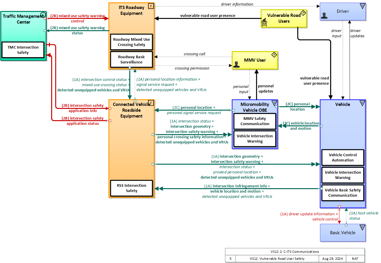
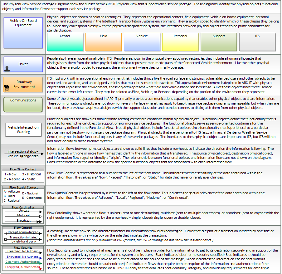
Includes Physical Objects:
| Physical Object | Class | Description |
|---|---|---|
| Basic Vehicle | Vehicle | 'Basic Vehicle' represents a complete operating vehicle. It includes the vehicle platform that interfaces with and hosts ITS electronics and all of the driver convenience and entertainment systems, and other non-ITS electronics on-board the vehicle. Interfaces represent both internal on-board interfaces between ITS equipment and other vehicle systems and other passive and active external interfaces or views of the vehicle that support vehicle/traffic monitoring and management. External interfaces may also represent equipment that is carried into the vehicle (e.g., a smartphone that is brought into the vehicle). Internal interfaces are often implemented through a vehicle databus, which is also included in this object. Note that 'Vehicle' represents the general functions and interfaces that are associated with personal automobiles as well as commercial vehicles, emergency vehicles, transit vehicles, and other specialized vehicles. |
| Connected Vehicle Roadside Equipment | Field | 'Connected Vehicle Roadside Equipment' (CV RSE) represents the Connected Vehicle roadside devices (i.e., Roadside Units (RSUs)) equipped with short range wireless (SRW) communications technology, as well as any other supporting equipment that leverage the RSU and are not described by other objects (e.g., a local roadside processor). CVRSE are used to send messages to, and receive messages from, nearby vehicles and personal devices equipped with compatible communications technology. Communications with adjacent field equipment and back office centers that monitor and control the RSE are also supported. This device operates from a fixed position and may be permanently deployed or a portable device that is located temporarily in the vicinity of a traffic incident, road construction, or a special event. It includes a processor, data storage, and communications capabilities that support secure communications with passing vehicles, other field equipment, and centers. |
| Driver | Vehicle | The 'Driver' represents the person that operates a vehicle on the roadway. Included are operators of private, transit, commercial, and emergency vehicles where the interactions are not particular to the type of vehicle (e.g., interactions supporting vehicle safety applications). The Driver originates driver requests and receives driver information that reflects the interactions which might be useful to all drivers, regardless of vehicle classification. Information and interactions which are unique to drivers of a specific vehicle type (e.g., fleet interactions with transit, commercial, or emergency vehicle drivers) are covered by separate objects. |
| ITS Roadway Equipment | Field | 'ITS Roadway Equipment' represents the ITS equipment that is distributed on and along the roadway that monitors and controls traffic and monitors and manages the roadway. This physical object includes traffic detectors, environmental sensors, traffic signals, highway advisory radios, dynamic message signs, CCTV cameras and video image processing systems, grade crossing warning systems, and ramp metering systems. Lane management systems and barrier systems that control access to transportation infrastructure such as roadways, bridges and tunnels are also included. This object also provides environmental monitoring including sensors that measure road conditions, surface weather, and vehicle emissions. Work zone systems including work zone surveillance, traffic control, driver warning, and work crew safety systems are also included. |
| Micromobility Vehicle OBE | Vehicle | The Micromobility Vehicle On-Board Equipment (MMV OBE) provides the vehicle-based sensory, processing, storage, and communications functions that support efficient, safe, and convenient travel. The MMV OBE includes general capabilities that apply to bicycles and other low-powered mobility devices such as e-scooters, powered wheelchairs, and power assisted bicycles. The MMV OBE includes the common interfaces and functions that could apply to any low-powered mobility device. The radio(s) supporting V2V and V2I communications are a key component of the MMV OBE. Both one-way and two-way communications options support a spectrum of information services from basic broadcast to advanced personalized information services. Advanced sensors, processors, and enhanced traveler interfaces (through PIDs), complement traveler information services so that, in addition to making informed mode and route selections, the vulnerable road user travels these routes in a safer and more consistent manner. |
| MMV User | Personal | The 'MMV User' represents the person that operates a micromobility vehicle (MMV). Included are cyclists and operators of other low-powered mobility devices such as e-scooters, powered wheelchairs, and power assisted bicycles where the interactions are not particular to the type of vehicle (e.g., interactions supporting vehicle safety applications). The MMV User participates in ITS services that support safe, shared use of the transportation network by motorized and non-motorized transportation modes. Representing those using non-motorized travel modes, and in particular bicyclists that sometimes share motor vehicle lanes, these MMV users provide input (e.g. a call signal requesting right of way at an intersection) and may be detected by ITS services to improve safety. The MMV User originates requests and receives information that reflects the interactions which might be useful to all users, regardless of vehicle type. |
| Pedestrian | Personal | The 'Pedestrian' represents a person traveling on foot. Pedestrians participate in ITS services that support safe, shared use of the transportation network. Included are visually impaired travelers who travel through portions of the transportation network and interact with ITS systems. They provide input (e.g. a call signal requesting right of way at an intersection) and may be detected by ITS services to improve safety |
| Personal Information Device | Personal | The 'Personal Information Device' provides the capability for travelers to receive formatted traveler information wherever they are. Capabilities include traveler information, trip planning, and route guidance. Frequently a smart phone, the Personal Information Device provides travelers with the capability to receive route planning and other personally focused transportation services from the infrastructure in the field, at home, at work, or while en-route. Personal Information Devices may operate independently or may be linked with vehicle on-board equipment. This subsystem also supports safety related services with the capability to broadcast safety messages and initiate a distress signal or request for help. |
| Traffic Management Center | Center | The 'Traffic Management Center' monitors and controls traffic and the road network. It represents centers that manage a broad range of transportation facilities including freeway systems, rural and suburban highway systems, and urban and suburban traffic control systems. It communicates with ITS Roadway Equipment and Connected Vehicle Roadside Equipment (RSE) to monitor and manage traffic flow and monitor the condition of the roadway, surrounding environmental conditions, and field equipment status. It manages traffic and transportation resources to support allied agencies in responding to, and recovering from, incidents ranging from minor traffic incidents through major disasters. |
| Vehicle | Vehicle | This 'Vehicle' physical object is used to model core capabilities that are common to more than one type of Vehicle. It provides the vehicle-based general sensory, processing, storage, and communications functions that support efficient, safe, and convenient travel. Many of these capabilities (e.g., see the Vehicle Safety service packages) apply to all vehicle types including personal vehicles (including motorcycles), commercial vehicles, emergency vehicles, transit vehicles, and maintenance vehicles. From this perspective, the Vehicle includes the common interfaces and functions that apply to all motorized vehicles. The radio(s) supporting V2V and V2I communications are a key component of the Vehicle. Both one-way and two-way communications options support a spectrum of information services from basic broadcast to advanced personalized information services. Advanced sensors, processors, enhanced driver interfaces, and actuators complement the driver information services so that, in addition to making informed mode and route selections, the driver travels these routes in a safer and more consistent manner. This physical object supports all six levels of driving automation as defined in SAE J3016. Initial collision avoidance functions provide 'vigilant co-pilot' driver warning capabilities. More advanced functions assume limited control of the vehicle to maintain lane position and safe headways. In the most advanced implementations, this Physical Object supports full automation of all aspects of the driving task, aided by communications with other vehicles in the vicinity and in coordination with supporting infrastructure subsystems. |
| Vulnerable Road Users | Personal | 'Vulnerable Road Users' represents any roadway user not in a motorized vehicle capable of operating at the posted speed for the roadway in question, and also any roadway user in a vehicle not designed to encase (and thus protect) its occupants. This includes pedestrians, cyclists, wheelchair users, two-wheeled scooter micromobility users, as well as powered scooters and motorcycles. Note that this terminator represents the physical properties of vulnerable road users and their conveyance that may be sensed to support safe vehicle automation and traffic management in mixed mode applications where a variety of road users share the right-of-way. See also 'Pedestrian' and 'MMV User' Physical Objects that represent the human interface to these vulnerable road users. |
Includes Functional Objects:
| Functional Object | Description | Physical Object |
|---|---|---|
| MMV Safety Communication | 'MMV Safety Communication' exchanges the current location and motion information of the MMV with other connected devices in the vicinity, uses that information to calculate traveler and vehicles paths, and warns the traveler when the potential for an impending collision is detected. If available, map data is used to filter and interpret the relative location and motion of connected devices in the vicinity. Information from the infrastructure, e.g., a TIC or CVRE, can be used to detect non-equipped travelers. MMV location and motion broadcasts are also received by the infrastructure and used by the infrastructure to support a wide range of roadside safety and mobility applications | Micromobility Vehicle OBE |
| Personal Pedestrian Safety | 'Personal Pedestrian Safety' improves pedestrian, cyclist, and other vulnerable road user safety by providing personal location information to the infrastructure that can be used to avoid collisions involving vulnerable road users. It may also alert the vulnerable road user of unsafe conditions, augmenting or extending information provided by signals and signs. The information provided and the user interface delivery mechanism (visual, audible, or haptic) can also be tailored to the needs of the user that is carrying or wearing the device that hosts the application. | Personal Information Device |
| Roadway Mixed Use Crossing Safety | 'Roadway Mixed Use Crossing Safety' is an advanced infrastructure application that detects pedestrians, cyclists, and other non-motorized users and provides active safety warnings to drivers when cross walks or other intersecting mixed use paths are occupied. | ITS Roadway Equipment |
| Roadway Surveillance | 'Roadway Basic Surveillance' monitors traffic conditions using fixed equipment such as loop detectors, CCTV cameras, , RADARs and LIDARs. | ITS Roadway Equipment |
| RSE Intersection Management | 'RSE Intersection Management' uses short range communications to support connected vehicle applications that manage signalized intersections. It communicates with approaching vehicles and ITS infrastructure (e.g., the traffic signal controller) to enhance traffic signal operations. Coordination with the ITS infrastructure also supports conflict monitoring to ensure the RSE output and traffic signal control output are consistent and degrade in a fail safe manner. This object also has the required functionalities for optimizing Signal Phase and Timing (SPaT), sending necessary commands to traffic signal controller to execute the optimized SPaT, and updating SPaT in real-time. | Connected Vehicle Roadside Equipment |
| RSE Intersection Safety | 'RSE Intersection Safety' uses short range communications to support connected vehicle applications that improve intersection safety. It matches information from multiple sensors or sources to produce vehicle or VRU location data with higher confidence than that from a sole sensor or source. It communicates with approaching vehicles and ITS infrastructure to alert and warn drivers of potential stop sign, red light, and non-motorized user crossing conflicts or violations. | Connected Vehicle Roadside Equipment |
| TMC Intersection Safety | 'TMC Intersection Safety' controls and monitors RSEs that support stop sign, red light, and mixed use crossing violations. It configures the RSEs for the current intersection geometry and traffic signal control equipment at the intersection. Information that is currently being communicated to passing vehicles and the operational status of the field equipment is monitored by this application. The operational status of the field equipment is reported to operations personnel. | Traffic Management Center |
| Vehicle Basic Safety Communication | 'Vehicle Basic Safety Communication' exchanges current vehicle characteristics, location, and motion (including past and intended maneuver) information with other vehicles in the vicinity and the infrastructure, uses that information to calculate vehicle paths, and warns the driver when the potential for an impending collision is detected. If available, map data is used to filter and interpret the relative location and motion of vehicles in the vicinity. Information from on-board sensors (e.g., radars and image processing) are also used, if available, in combination with the V2V communications to detect non-equipped vehicles and corroborate connected vehicle data. This object represents a broad range of implementations ranging from basic Vehicle Awareness Devices that only broadcast vehicle location and motion and provide no driver warnings to advanced integrated safety systems that coordinate maneuvers and may, in addition to warning the driver, provide collision warning information to support automated control functions that can support control intervention. This object can also support broadcasting other vehicle information required for passing through a specific roadway segment such as variables that describe vehicle's characteristics and parameters, driver's preferences in terms of vehicle motion and behavior, etc. | Vehicle |
| Vehicle Control Automation | 'Vehicle Control Automation' provides lateral and/or longitudinal control of a vehicle to allow 'hands off' and/or 'feet off' driving, automating the steering, accelerator, and brake control functions. It builds on the sensors included in 'Vehicle Safety Monitoring' and 'Vehicle Control Warning', receives warnings from 'Vehicle Intersection Movement', and uses the information about the area surrounding the vehicle to safely control the vehicle. It covers the range of incremental control capabilities from driver assistance systems that take over steering or acceleration/deceleration in limited scenarios with direct monitoring by the driver to full automation where all aspects of driving are automated under all roadway and environmental conditions, including providing, receiving, and acting on cooperation-related messaging. | Vehicle |
| Vehicle Control Warning | 'Vehicle Control Warning' monitors areas around the vehicle and provides warnings to a driver so the driver can take action to recover and maintain safe control of the vehicle. It includes lateral warning systems that warn of lane departures and obstacles or vehicles to the sides of the vehicle and longitudinal warning systems that monitor areas in the vehicle path and provide warnings when headways are insufficient or obstacles are detected in front of or behind the vehicle. It includes on-board sensors, including radars and imaging systems, and the driver information system that provides the visual, audible, and/or haptic warnings to the driver. | Vehicle |
| Vehicle Intersection Movement | 'Vehicle Intersection Movement' uses short-range wireless communications to monitor other connected vehicles at intersections and support the safe movement of the vehicle through the intersection by receiving and processing signal phase and timing messages from the intersection. Driver warnings are provided and the application may also optionally take control of the vehicle to avoid collisions, in coordination with Vehicle Control Automation. The application will also notify the infrastructure and other vehicles if it detects an unsafe infringement on the intersection. | Vehicle |
Includes Information Flows:
| Information Flow | Description |
|---|---|
| crossing call | Non-motorized user request to cross the roadway. This is an overt request from a pedestrian, micromobility vehicle user (e.g., cyclist), or other vulnerable road user. This overt request may be a physical button push or hovering or gesturing in the vicinity of the button that supports contactless activation. |
| crossing permission | Information provided to guide and warn pedestrians, micromobility vehicle users (e.g., cyclists), and other crosswalk users. It includes crossing request acknowledgment, current crossing permission, crossing time remaining, and real-time warnings of safety threats. |
| detected unequipped vehicles and VRUs | Notification of a nearby vehicle (light vehicle, commercial vehicle, MMV etc.) or vulnerable road user that does not appear to be equipped with a short range communications device but is detectable using onboard vehicle or infrastructure sensors. The flow communicates detected vehicle/VRU location, physical characteristics, observable kinematics and confidence in those measures. |
| driver information | Regulatory, warning, guidance, and other information provided to the driver to support safe and efficient vehicle operation. |
| driver input | Driver input to the vehicle on-board equipment including configuration data, settings and preferences, interactive requests, and control commands. |
| driver update information | Information provided to the driver-vehicle interface to inform the driver about current conditions, potential hazards, and the current status of vehicle on-board equipment. The flow includes the information to be presented to the driver and associated metadata that supports processing, prioritization, and presentation by the DVI as visual displays, audible information and warnings, and/or haptic feedback. |
| driver updates | Information provided to the driver including visual displays, audible information and warnings, and haptic feedback. The updates inform the driver about current conditions, potential hazards, and the current status of vehicle on-board equipment. |
| host vehicle status | Information provided to the ITS on-board equipment from other systems on the vehicle platform. This includes the current status of the powertrain, steering, and braking systems, and status of other safety and convenience systems. In implementations where GPS is not integrated into the Vehicle On-Board Equipment, the host vehicle is also the source for data describing the vehicle's location in three dimensions (latitude, longitude, elevation) and accurate time that can be used for time synchronization across the ITS environment. |
| intersection control status | Status data provided by the traffic signal controller including phase information, alarm status, and priority/preempt status. |
| intersection geometry | The physical geometry of an intersection covering the location and width of each approaching lane, egress lane, and valid paths between approaches and egresses. This flow also defines the location of stop lines, cross walks, specific traffic law restrictions for the intersection (e.g., turning movement restrictions), and other elements that support calculation of a safe and legal vehicle path through the intersection. |
| intersection infringement detection | Notification of a detected unpermitted movement at an intersection such as a stop sign violation or running a red light. |
| intersection infringement info | Vehicle path information sent by a vehicle that is performing an unpermitted movement at an intersection such as a stop sign violation or running a red light. This also includes information about possible conflicts with other road users in the vehicle's path, including a range of uncontrolled intersection scenarios that could be covered by this flow. This flow does not include permanent ids; only temporary ones that allow monitoring of the vehicle as it moves across the intersection. |
| intersection safety application info | Intersection and device configuration data, including intersection geometry, and warning parameters and thresholds. This flow also supports remote control of the application so the application can be taken offline, reset, or restarted. |
| intersection safety application status | Infrastructure safety application status reported by the RSE. This includes current operational state and status of the RSE and a record of intersection safety issues identified and alerts and warnings issued. |
| intersection safety warning | A warning of an imminent unsafe vehicle infringement at an intersection that may endanger other vehicles or pedestrians. This allows vehicles approaching the intersection to be warned in the event of an imminent red light or stop sign violation or potential infringement on an occupied crosswalk. All connected vehicles and personal devices near the intersection receive the warning. |
| intersection status | Current signal phase and timing information for all lanes at a signalized intersection. This flow identifies active lanes and lanes that are being stopped and specifies the length of time that the current state will persist for each lane. It also identifies signal priority and preemption status and pedestrian crossing status information where applicable. It may also include future signal phase and timing information. |
| mixed use crossing status | Current pedestrian and other mixed use crossing information including an indication of whether the call button has been activated, the current state of the mixed use crossing signal, and information indicating whether non-motorized users are currently occupying the cross walk. |
| mixed use safety warning control | Configuration and control of equipment that monitors and manages mixed use crossings and provides visual displays and warnings to drivers when non-motorized users are occupying a cross walk or other mixed use path crossing. |
| mixed use safety warning status | Current operational status and state of pedestrian crossings and other mixed use path crossing warning systems. |
| personal crossing safety information | Current crossing status including permission to cross, crossing time remaining, and warnings (e.g., a vehicle's trajectory may impact non-motorized users including pedestrians and cyclists). |
| personal input | User input to a personal device. This flow may request traveler information, request right of way, summon assistance, make a reservation, or request any other traveler service. This flow also establishes the settings that tailor each application to suit the user's needs. |
| personal location | The current location (latitude, longitude, and elevation) reported by the personal information or safety device |
| personal location information | Pedestrian, bicyclist, and other non-motorized user locations at an intersection as detected and reported by an RSE. |
| personal signal service request | A request for right of way from a personal device that indicates the type of traveler (pedestrian, special needs pedestrian, bicyclist, etc.), anticipated time of arrival, travel path, and crossing duration. |
| personal updates | Personal information, alerts, and warnings provided to pedestrians, micromobility vehicle (MMV) users, work crew members, and other individuals in a mixed use area. This includes visual, audio, and haptic outputs that may be customized to support individual needs. |
| proxied personal location | Relay of pedestrian, bicyclist, and other non-motorized user locations at an intersection. This relay or rebroadcast of personal locations supports coordination between motorized and non-motorized users that do not have interoperable communications capability. |
| signal service request | A call for service or extension for a signal control phase that is issued by the RSE for connected vehicles approaching an intersection and/or pedestrians at a crosswalk. This flow identifies the desired phase and service time. |
| vehicle control | Control commands issued to vehicle actuators that control steering, throttle, and braking and other related commands that support safe transition between manual and automated vehicle control. This flow can also deploy restraints and other safety systems when a collision is unavoidable. |
| vehicle location and motion | Data describing the vehicle's location in three dimensions, heading, speed, acceleration, braking status, and size. |
| vehicle path prediction | The predicted future vehicle path of travel. This flow includes an indication of the future positions of the transmitting vehicle that can be used by receiving vehicles to support coordinated driving maneuvers and enhance in-lane and out-of-lane threat classification. |
| vulnerable road user presence | Detection of pedestrians, cyclists, and other vulnerable road users. This detection is based on physical characteristics of the user and their conveyance, which may be enhanced by design and materials that facilitate sensor-based detection and tracking of vulnerable road users. |
Goals and Objectives
Associated Planning Factors and Goals
| Planning Factor | Goal |
|---|---|
| A. Support the economic vitality of the metropolitan area, especially by enabling global competitiveness, productivity, and efficiency; | Improve freight network |
| B. Increase the safety of the transportation system for motorized and nonmotorized users; | Reduce fatalities and injuries |
| D. Increase the accessibility and mobility of people and for freight; | Reduce congestion |
| G. Promote efficient system management and operation; | Improve efficiency |
| I. Improve the resiliency and reliability of the transportation system and reduce or mitigate stormwater impacts of surface transportation; | Improve resiliency and reliability |
Associated Objective Categories 
Associated Objectives and Performance Measures
Needs and Requirements
| Need | Functional Object | Requirement | ||
|---|---|---|---|---|
| 01 | Traffic Operations needs to be able to provide to connected vehicles an indication that pedestrians or micromobility vehicle users may be crossing or are crossing an intersection in order to reduce the likelihood of the vehicle striking the pedestrian or micromobility users. | Personal Pedestrian Safety | 01 | The personal information device shall provide the current location (latitude, longitude, and elevation) of the non-motorized travelers. |
| Roadway Mixed Use Crossing Safety | 01 | The field element shall collect images or sensor data for pedestrians or bicyclists and respond to pedestrian or bicyclist crossing requests via display, audio signal, or other manner. | ||
| Roadway Surveillance | 07 | The field element shall detect vehicles and vulnerable road users and share this information with roadside communications equipment. This supports detection of vehicles and vulnerable road users that do not have operable short range communications capabilities. | ||
| RSE Intersection Management | 01 | The field element shall communicate with passing vehicles to provide the current signal phase and timing information for all lanes and approaches at a signalized intersection. | ||
| 02 | The field element shall send the request for emergency vehicle preemption to a traffic signal controller that results in preemption of the current control plan and grants right-of-way to the requesting vehicle. | |||
| RSE Intersection Safety | 01 | The roadway equipment shall collect the current location (latitude, longitude, and elevation) from personal information devices. | ||
| TMC Intersection Safety | 02 | The center shall provide warnings to drivers when non-motorized users are occupying a cross walk or other mixed use path crossing. | ||
| 02 | Traffic Operations needs to be able to warn pedestrians or micromobility vehicle users about crossing status or potential vehicle infringement into the crosswalk in order to allow the pedestrian or micromobility vehicle users to safely cross an intersection. | Personal Pedestrian Safety | 03 | The personal traveler interface shall provide traveler location information to transit vehicles. |
| Roadway Surveillance | 07 | The field element shall detect vehicles and vulnerable road users and share this information with roadside communications equipment. This supports detection of vehicles and vulnerable road users that do not have operable short range communications capabilities. | ||
| RSE Intersection Management | 01 | The field element shall communicate with passing vehicles to provide the current signal phase and timing information for all lanes and approaches at a signalized intersection. | ||
| 02 | The field element shall send the request for emergency vehicle preemption to a traffic signal controller that results in preemption of the current control plan and grants right-of-way to the requesting vehicle. | |||
| RSE Intersection Safety | 03 | The roadway equipment shall collect vehicle path information sent by a vehicle. | ||
| TMC Intersection Safety | 01 | The center shall provide current intersection safety status information. | ||
| 03 | The center shall provide warnings to pedestrians or bicyclists when vehicles are infringing on a cross walk or other mixed use path crossing. | |||
| Vehicle Basic Safety Communication | 06 | The vehicle shall exchange location and motion information with roadside equipment and nearby vehicles. | ||
| Vehicle Intersection Movement | 02 | The vehicle shall provide data describing the vehicle's location in three dimensions, heading, speed, acceleration, braking status, and size. | ||
| 03 | Traffic Operations needs to be able to provide intersection priority for pedestrians or micromobility vehicle users based upon requests from the pedestrians or micromobility vehicle users. | RSE Intersection Safety | 01 | The roadway equipment shall collect the current location (latitude, longitude, and elevation) from personal information devices. |
| TMC Intersection Safety | 01 | The center shall provide current intersection safety status information. | ||
| 04 | The field element shall be capable of providing intersection priority for pedestrians or bicyclists based upon requests from the pedestrians or bicyclists | |||
| 04 | Traffic Operations needs to be able to inform pedestrians and micromobility vehicle users of the status of the intersection including the amount of time left for crossing the intersection. | Roadway Mixed Use Crossing Safety | 02 | The field element shall respond to pedestrian or bicyclist crossing requests via display, audio signal, or other manner. |
| 03 | The field element shall inform pedestrians and bicyclists of the status of the intersection including the amount of time left for crossing the intersection. | |||
| RSE Intersection Management | 01 | The field element shall communicate with passing vehicles to provide the current signal phase and timing information for all lanes and approaches at a signalized intersection. | ||
| 02 | The field element shall send the request for emergency vehicle preemption to a traffic signal controller that results in preemption of the current control plan and grants right-of-way to the requesting vehicle. | |||
| 03 | The field element shall send the infrastructure application status to the operations center. | |||
| 09 | The field element shall collect current signal phase and timing data from the traffic signal controller. | |||
| RSE Intersection Safety | 04 | The roadway equipment shall provide current crossing status including permission to cross, crossing time remaining. | ||
| 05 | The Driver needs to receive warnings or have the vehicle automatically perform control actions relating to pedestrians, and vulnerable road users that are sharing the roadway with the vehicle. | MMV Safety Communication | 03 | The micromobility vehicle shall exchange location and motion information of the micromobility vehicle to nearby vehicles to warn the micromobility vehicle users of an impending collision. |
| 04 | The micromobility vehicle shall receive information from roadway equipment about approaching vehicles to alert and warn micromobility vehicle users of potential stop sign, red light, and non-motorized user crossing conflicts or violations. | |||
| Roadway Surveillance | 07 | The field element shall detect vehicles and vulnerable road users and share this information with roadside communications equipment. This supports detection of vehicles and vulnerable road users that do not have operable short range communications capabilities. | ||
| RSE Intersection Safety | 02 | The roadway equipment shall communicate with approaching vehicles to alert and warn drivers of potential stop sign, red light, and non-motorized user crossing conflicts or violations. | ||
| Vehicle Control Automation | 04 | The vehicle shall collect location and motion data from the vehicle platform. | ||
| 14 | The vehicle shall be capable of performing control actions based upon warnings received regarding pedestrians, cyclists, and other non-motorized users that are sharing the roadway with the vehicle | |||
| Vehicle Control Warning | 01 | The vehicle shall monitor the area to the sides of the vehicle to determine the proximity of other objects to the vehicle and if a warning is needed. | ||
| 02 | The vehicle shall evaluate the likelihood of a collision between two vehicles or a vehicle and another object to warn the driver, based on the proximity and vectors of other objects to the vehicle, roadway characteristics, and the current speed and direction of the vehicle. | |||
| 03 | The vehicle shall provide position warnings to the driver when an object gets close enough to the vehicle to become a hazard if no action is taken by the driver. | |||
| 04 | The vehicle shall present vehicle control warnings information to the driver in audible or visual forms without impairing the driver's ability to control the vehicle in a safe manner. | |||
| 05 | The vehicle shall provide warnings to the driver based on information received from other vehicles regarding potentially hazardous road conditions, road hazards, or pending/in-progress vehicle maneuvers. | |||
| Vehicle Intersection Movement | 04 | The vehicle shall be capable of providing warnings to the driver based upon information received regarding pedestrians, cyclists, and other non-motorized users that are sharing the roadway with the vehicle. | ||
| 06 | Pedestrians need to be informed about potentially hazardous road conditions or vehicles that may pose a danger to them. | Personal Pedestrian Safety | 013 | The personal traveler interface shall inform travelers about hazardous road conditions. |
| Roadway Mixed Use Crossing Safety | 04 | The field element shall provide safety warnings to pedestrians. | ||
| Roadway Surveillance | 07 | The field element shall detect vehicles and vulnerable road users and share this information with roadside communications equipment. This supports detection of vehicles and vulnerable road users that do not have operable short range communications capabilities. | ||
| 07 | MMV Operators need to be informed about potentially hazardous road conditions or vehicles that may pose a danger to them. | Personal Pedestrian Safety | 033 | The personal traveler interface shall inform MMV operators about hazardous road conditions. |
| Roadway Mixed Use Crossing Safety | 05 | The field element shall provide safety warnings to MMV operators. | ||
| Roadway Surveillance | 07 | The field element shall detect vehicles and vulnerable road users and share this information with roadside communications equipment. This supports detection of vehicles and vulnerable road users that do not have operable short range communications capabilities. | ||
Related Sources
| Document Name | Version | Publication Date |
|---|---|---|
| None |
Security
In order to participate in this service package, each physical object should meet or exceed the following security levels.
| Physical Object Security | ||||
|---|---|---|---|---|
| Physical Object | Confidentiality | Integrity | Availability | Security Class |
| Basic Vehicle | ||||
| Connected Vehicle Roadside Equipment | Moderate | High | Moderate | Class 3 |
| ITS Roadway Equipment | Moderate | High | Moderate | Class 3 |
| Micromobility Vehicle OBE | Low | High | Moderate | Class 3 |
| Personal Information Device | Low | High | Moderate | Class 3 |
| Traffic Management Center | Moderate | Moderate | Low | Class 2 |
| Vehicle | Low | High | Moderate | Class 3 |
| Vulnerable Road Users | ||||
In order to participate in this service package, each information flow triple should meet or exceed the following security levels.
| Information Flow Security | |||||
|---|---|---|---|---|---|
| Source | Destination | Information Flow | Confidentiality | Integrity | Availability |
| Basis | Basis | Basis | |||
| Basic Vehicle | Vehicle | host vehicle status | Low | Moderate | High |
| Unlikely that this includes any information that could be used against the originator. | This can be MODERATE or HIGH, depending on the application: This is used later on to determine whether a vehicle is likely going to violate a red light or infringe a work zone. This needs to be correct in order for the application to work correctly. | Since this monitors the health and safety of the vehicle and that information is eventually reported to the driver, it should be available at all times as it directly affects vehicle and operator safety. | |||
| Connected Vehicle Roadside Equipment | ITS Roadway Equipment | detected unequipped vehicles and VRUs | Moderate | High | Moderate |
| This data is intended to be shared with all nearby vehicles, traffic control devices and vulnerable road users; it is essentially public. However, all communications between field infrastructure should be protected from viewing to prevent attackers from analyzing traffic and developing attack methods. | This data may be used as input to vehicle situational awareness and thus trigger crash-avoidance actions. If manipulated or incorrect, a crash may occur; though vehicles able to use this data also have sensory capabilities, this flow will often contain data describing objects/vehicles/VRUs that are obscured and not observable by on-board sensors. | This data may be used as input to vehicle situational awareness and thus trigger crash-avoidance actions. This data enable collision avoidance actions that are impractical without it, as vehicles able to use this data to sense-by-proxy other vehicles/VRUs/obstacles that are obscured by on-board sensors. Considered MODERATE and not HIGH only because the lack of availability reverts to existing operations and does not actively make safety worse. | |||
| Connected Vehicle Roadside Equipment | ITS Roadway Equipment | personal location information | Moderate | Moderate | Low |
| This is simply passing on received broadcast messages. It is intended to be received by everyone; however, all communications between field infrastructure should be protected from viewing to prevent attackers from analyzing traffic and developing attack methods. | We assume that this information is not able to cause the ITS RE to behave in extreme ways, e.g. to keep all the lights red forever because it thinks there’s a baby in the middle of the road. In other words, the ITS RE has maximum durations for the different phases of the cycle which it will not go beyond not matter what this information flow contains. Bad information can cause annoyances and disrupt traffic flow to a limited extent but will not have a large impact. NYC: location should be accurate and should not be tampered; however, we assume the info is not able to cause the ITS RE to behave in extreme ways (i.e., there should be maximum different cycle phases) | If this is down, the ITS RE goes back to default behavior, which we assume is set sensibly. NYC: if down, the ITS RE should revert to default behavior which we assume is sensible | |||
| Connected Vehicle Roadside Equipment | ITS Roadway Equipment | signal service request | Moderate | Moderate | Low |
| info is not confidential and could be exposed with little harm to participants; however, all communications between field infrastructure should be protected from viewing to prevent attackers from analyzing traffic and developing attack methods. | requests should be accurate and not tampered with, otherwise incorrect or malicious requests could be granted which could lead to delays | requests should be timely and available immediately but availability cannot be guaranteed over a wireless medium; also worst case scenario is the vehicle or pedestrian has to wait for the appropriate signal | |||
| Connected Vehicle Roadside Equipment | Micromobility Vehicle OBE | personal crossing safety information | Not Applicable | Moderate | Low |
| This data is intentionally transmitted to everyone via a broadcast. It can also be determined via other visual indicators. | People will use this information to determine if they can cross, so incorrect information increases the risk of accidents. DISC: THEA believes this to be HIGH: "info needs to be accurate and should not be tampered with (used to warn pedestrians of infringement, etc.); higher because enables accessibility; pedestrians may not be able to see/hear the information" | If this is down, the pedestrian still gets information from the RE and from the rest of the environment. DISC: NYC and THEA believe this to be MODERATE: info needs to be accurate and should not be tampered with (used to warn pedestrians of infringement, etc.); higher because enables accessibility; pedestrians may not be able to see/hear the information; however, overall I level is M, not H, because message is still just information and pedestrian needs to use their own awareness A: needs to be readily available to give permission to cross, time remaining, etc. but cannot guarantee wireless communication; however, worst case is the pedestrian has to wait; also cannot guarantee wireless communication | |||
| Connected Vehicle Roadside Equipment | Personal Information Device | detected unequipped vehicles and VRUs | Not Applicable | High | Moderate |
| This data is intended to be shared with all nearby vehicles, traffic control devices and vulnerable road users; it is essentially public. | This data may be used as input to vehicle situational awareness and thus trigger crash-avoidance actions. If manipulated or incorrect, a crash may occur; though vehicles able to use this data also have sensory capabilities, this flow will often contain data describing objects/vehicles/VRUs that are obscured and not observable by on-board sensors. | This data may be used as input to vehicle situational awareness and thus trigger crash-avoidance actions. This data enable collision avoidance actions that are impractical without it, as vehicles able to use this data to sense-by-proxy other vehicles/VRUs/obstacles that are obscured by on-board sensors. Considered MODERATE and not HIGH only because the lack of availability reverts to existing operations and does not actively make safety worse. | |||
| Connected Vehicle Roadside Equipment | Personal Information Device | intersection geometry | Low | High | Moderate |
| Map data intended for general use by any C-ITS component than needs it. No information here includes PII or anything else that, if viewed by someone other than the participant, would lead to harm. | Map data is used for a host of application purposes. This widespread use means that any corruption in the data has a widespread and far reaching effect. | Occasional outages of this flow will delay updates and lead to a loss of accurate function of some applications. Depending on the application this could be HIGH. | |||
| Connected Vehicle Roadside Equipment | Personal Information Device | intersection safety warning | Not Applicable | High | Moderate |
| This data is intentionally transmitted to everyone via a broadcast. It can also be determined via other visual indicators. | This message is broadcast as a warning, allowing infringing drivers to avoid a collision with a pedestrian and all other drivers to avoid the infringing driver. If this message is falsely broadcast it could cause drivers who think they may be infringing to break suddenly, increasing the chance of a collisions from behind. If it were constantly broadcast incorrectly, it may lead to drivers ignoring this notifications. All of these cases have an impact on safety. NYC believes some scenarios may only require MODERATE, but some do require HIGH. | This message has a very short window in which it is valid. If it is not delivered until after the driver has passed the point of no return before entering the crosswalk, they will not gain any information from it, rendering the application useless. | |||
| Connected Vehicle Roadside Equipment | Personal Information Device | intersection status | Not Applicable | High | Moderate |
| This data is intended for all vehicles in the immediate area of the sender. | info needs to be accurate and should not be tampered so the vehicle OBE has correct SPaT info for all lanes; however the driver can still see the traffic signals. From NYC: This information will be used by the vehicle ASD to determine whether or not to issue a red light violation warning to the driver. False information could lead to the vehicle ASD not issuing a warning when in fact it should have. The vehicle operator is not using this information to decide whether or not to travel through the intersection. They will still have visual cues, such as traffic lights, indicating whether or not they can travel through the intersection. | needs to be available so the vehicle OBE has correct SPaT info; identifies signal priority and preemption status and pedestrian crossing status information, etc. However availability cannot be guaranteed over a wireless medium. From NYC: Without this information, vehicle ASD may not properly issue a red light violation warning to the driver. The vehicle operator will still use the traffic | |||
| Connected Vehicle Roadside Equipment | Personal Information Device | personal crossing safety information | Not Applicable | Moderate | Low |
| This data is intentionally transmitted to everyone via a broadcast. It can also be determined via other visual indicators. | People will use this information to determine if they can cross, so incorrect information increases the risk of accidents. DISC: THEA believes this to be HIGH: "info needs to be accurate and should not be tampered with (used to warn pedestrians of infringement, etc.); higher because enables accessibility; pedestrians may not be able to see/hear the information" | If this is down, the pedestrian still gets information from the RE and from the rest of the environment. DISC: NYC and THEA believe this to be MODERATE: info needs to be accurate and should not be tampered with (used to warn pedestrians of infringement, etc.); higher because enables accessibility; pedestrians may not be able to see/hear the information; however, overall I level is M, not H, because message is still just information and pedestrian needs to use their own awareness A: needs to be readily available to give permission to cross, time remaining, etc. but cannot guarantee wireless communication; however, worst case is the pedestrian has to wait; also cannot guarantee wireless communication | |||
| Connected Vehicle Roadside Equipment | Traffic Management Center | intersection safety application status | Moderate | Moderate | Low |
| This information could be of interest to a malicious individual who is attempting to determine the best way to accomplish a crime. As such it would be best to not make it easily accessible. DISC: THEA and NYC believe this may be LOW for some applications | If this is compromised, it could send unnecessary maintenance workers, or cause the appearance of excessive traffic violations, leading to further unnecessary investigation. NYC: should be able to cope with some bad information on the status and record of alerts/warnings; aggregate info; however could cause appearance of excessive traffic violations or unnecessary maintenance caused if data is compromised | A delay in reporting this may cause a delay in necessary maintenance, but (a) this is not time-critical and (b) there are other channels for reporting malfunctioning. Additionally, there is a message received notification, which means that RSE can ensure that all intersection safety issues are delivered. | |||
| Connected Vehicle Roadside Equipment | Vehicle | detected unequipped vehicles and VRUs | Not Applicable | High | Moderate |
| This data is intended to be shared with all nearby vehicles, traffic control devices and vulnerable road users; it is essentially public. | This data may be used as input to vehicle situational awareness and thus trigger crash-avoidance actions. If manipulated or incorrect, a crash may occur; though vehicles able to use this data also have sensory capabilities, this flow will often contain data describing objects/vehicles/VRUs that are obscured and not observable by on-board sensors. | This data may be used as input to vehicle situational awareness and thus trigger crash-avoidance actions. This data enable collision avoidance actions that are impractical without it, as vehicles able to use this data to sense-by-proxy other vehicles/VRUs/obstacles that are obscured by on-board sensors. Considered MODERATE and not HIGH only because the lack of availability reverts to existing operations and does not actively make safety worse. | |||
| Connected Vehicle Roadside Equipment | Vehicle | intersection geometry | Low | High | Moderate |
| Map data intended for general use by any C-ITS component than needs it. No information here includes PII or anything else that, if viewed by someone other than the participant, would lead to harm. | Map data is used for a host of application purposes. This widespread use means that any corruption in the data has a widespread and far reaching effect. | Occasional outages of this flow will delay updates and lead to a loss of accurate function of some applications. Depending on the application this could be HIGH. | |||
| Connected Vehicle Roadside Equipment | Vehicle | intersection safety warning | Not Applicable | High | Moderate |
| This data is intentionally transmitted to everyone via a broadcast. It can also be determined via other visual indicators. | This message is broadcast as a warning, allowing infringing drivers to avoid a collision with a pedestrian and all other drivers to avoid the infringing driver. If this message is falsely broadcast it could cause drivers who think they may be infringing to break suddenly, increasing the chance of a collisions from behind. If it were constantly broadcast incorrectly, it may lead to drivers ignoring this notifications. All of these cases have an impact on safety. NYC believes some scenarios may only require MODERATE, but some do require HIGH. | This message has a very short window in which it is valid. If it is not delivered until after the driver has passed the point of no return before entering the crosswalk, they will not gain any information from it, rendering the application useless. | |||
| Connected Vehicle Roadside Equipment | Vehicle | intersection status | Not Applicable | High | Moderate |
| This data is intended for all vehicles in the immediate area of the sender. | If this is compromised, the Vehicle OBE will receive messages that are inconsistent with what the traffic signals are displaying. This could lead to confusion and reduce the ability of the application to provide value. | If this is down, the Vehicle OBE doesn’t get the information it needs to stay in synch with the actual signal state, reducing or eliminating the value add from having this application. We assume that the Vehicle OBE will detect a lack of availability and choose not to send out-of-date information, so a failure of availability cannot have worse consequences than a failure of integrity which we have previously assessed at MEDIUM. | |||
| Connected Vehicle Roadside Equipment | Vehicle | proxied personal location | Not Applicable | Moderate | Moderate |
| This information is intended for widespread local distribution; effectively broadcast to every mobile device in the area. | Incorrect information could lead to a person not being properly located by a receiving vehicle, which could have catastrophic effects. | This data is required for the system to operate properly. If this data is not available, the system cannot give accurate warning information. | |||
| Driver | Vehicle | driver input | Moderate | High | High |
| Data included in this flow may include origin and destination information, which should be protected from other's viewing as it may compromise the driver's privacy. | Commands from from the driver to the vehicle must be correct or the vehicle may behave in an unpredictable and possibly unsafe manner | Commands must always be able to be given or the driver has no control. | |||
| ITS Roadway Equipment | Connected Vehicle Roadside Equipment | detected unequipped vehicles and VRUs | Moderate | High | Moderate |
| This data is intended to be shared with all nearby vehicles, traffic control devices and vulnerable road users; it is essentially public. However, all communications between field infrastructure should be protected from viewing to prevent attackers from analyzing traffic and developing attack methods. | This data may be used as input to vehicle situational awareness and thus trigger crash-avoidance actions. If manipulated or incorrect, a crash may occur; though vehicles able to use this data also have sensory capabilities, this flow will often contain data describing objects/vehicles/VRUs that are obscured and not observable by on-board sensors. | This data may be used as input to vehicle situational awareness and thus trigger crash-avoidance actions. This data enable collision avoidance actions that are impractical without it, as vehicles able to use this data to sense-by-proxy other vehicles/VRUs/obstacles that are obscured by on-board sensors. Considered MODERATE and not HIGH only because the lack of availability reverts to existing operations and does not actively make safety worse. | |||
| ITS Roadway Equipment | Connected Vehicle Roadside Equipment | intersection control status | Moderate | High | Moderate |
| This data is intentionally transmitted to everyone via a While this information is broadcast and can also be determined via other visual indicators, all communications between field infrastructure should be protected from viewing to prevent attackers from analyzing traffic and developing attack methods. | If this is compromised, the Roadway Equipment and Roadside Equipment will be sending messages that are inconsistent with each other, leading to confusion and possible accidents. | If this is down, the RSE doesn’t get the information it needs to stay in synch with the actual signal state, reducing or eliminating the value add from having this application. The RSE must detect a lack of availability and choose not to send out-of-date information, so a failure of availability could be interpreted as having the same value as Integrity. However, this data is semi-predictable and there are other indicators (such as the lights themselves) of the intersection status. From NYC, who believe this should be HIGH for some applications: If this is down, the RSE doesn’t get the information it needs to stay in synch with the actual signal state, reducing or eliminating the value add from having this application. The RSE must detect a lack of availability and choose not to send out-of-date information, so a failure of availability cannot have worse consequences than a failure of integrity which we have previously assessed at HIGH. | |||
| ITS Roadway Equipment | Connected Vehicle Roadside Equipment | intersection infringement detection | Moderate | High | Moderate |
| This data is intentionally transmitted to everyone via a While this information is broadcast and can also be determined via other visual indicators, all communications between field infrastructure should be protected from viewing to prevent attackers from analyzing traffic and developing attack methods. | This message is an indication of a potential hazard and should not be easy to forge. False messages here may lead to confusion that causes a traffic accident. | This message is an indication of a potential hazard. If it isn’t received it increases the risk to other road users. If a vehicle is infringing on an intersection, it must report this. | |||
| ITS Roadway Equipment | Connected Vehicle Roadside Equipment | mixed use crossing status | Moderate | High | Moderate |
| This data can be ascertained by examining indicators, but all communications between field infrastructure should be protected from viewing to prevent attackers from analyzing traffic and developing attack methods. | If this is compromised, the ITS RE and RSE will be sending messages that are inconsistent with each other, leading to confusion and possible accidents and reducing the ability of the application to provide value. If this information is incorrect, it could lead to a collision between a vehicle and a pedestrian. | If this is down, the RSE doesn’t get the information it needs to stay in synch with the actual signal state, reducing or eliminating the value add from having the RSE. We assume that the RSE will detect a lack of availability and choose not to send out-of-date information, so a failure of availability cannot have worse consequences than a failure of integrity which we have previously assessed at MEDIUM. | |||
| ITS Roadway Equipment | Driver | driver information | Not Applicable | High | Moderate |
| This data is sent to all drivers and is also directly observable, by design. | This is the primary signal trusted by the driver to decide whether to go through the intersection and what speed to go through the intersection at; if it’s wrong, accidents could happen. | If the lights are out you have to get a policeman to direct traffic – expensive and inefficient and may cause a cascading effect due to lack of coordination with other intersections. | |||
| ITS Roadway Equipment | MMV User | crossing permission | Not Applicable | High | Low |
| This data is intentionally transmitted to everyone via a broadcast. | Although pedestrians have a responsibility to make sure the road is safe before they cross, they may react instinctively to incorrect information and be led to cross at unsafe times if they get incorrect information. Also, if the traffic signals are wrong and an accident happens, the pedestrian involved could sue, causing financial loss and other undesirable outcomes. | It is easy to tell whether this information flow is available and pedestrians are used to using crosswalks that do not provide this service. | |||
| ITS Roadway Equipment | Pedestrian | crossing permission | Not Applicable | High | Low |
| This data is intentionally transmitted to everyone via a broadcast. | Although pedestrians have a responsibility to make sure the road is safe before they cross, they may react instinctively to incorrect information and be led to cross at unsafe times if they get incorrect information. Also, if the traffic signals are wrong and an accident happens, the pedestrian involved could sue, causing financial loss and other undesirable outcomes. | It is easy to tell whether this information flow is available and pedestrians are used to using crosswalks that do not provide this service. | |||
| ITS Roadway Equipment | Traffic Management Center | mixed use safety warning status | Low | Moderate | Low |
| Unless otherwise determined by the supplier (for example, because this flow contains proprietary or security-sensitive information about the device). | If this is compromised, the TMC might for example send maintenance teams to fix a traffic signal that isn’t broken, incurring unnecessary expense. | A delay in reporting the state of the ITS RE may lead to a delay in providing necessary maintenance, but (a) this is not time-critical and (b) there are other channels for reporting malfunctioning ITS REs. | |||
| Micromobility Vehicle OBE | Connected Vehicle Roadside Equipment | personal location | Not Applicable | High | Moderate |
| This data is intentionally transmitted to everyone via a broadcast. It can also be determined via other visual indicators. | An incorrect location message could lead to a false warning or lack of warning. A lack of warning can have obvious catastrophic consequences, while a false warning could lead to users ignoring warnings due to perceived inaccuracy. Given that this triple may apply to highly dynamic environments (such as work zones), its accuracy is paramount, and thus if sent, must have HIGH integrity. | There are other visual indicators about the geofenced areas. PID users in dynamic environments (incident and work zones) should know when they are leaving a geofenced area. As long as they remain in the geofenced area, this information is not as necessary. Not all pedestrians will carry a personal information device, and the system should be able to operate without this information. | |||
| Micromobility Vehicle OBE | Connected Vehicle Roadside Equipment | personal signal service request | Low | Moderate | Low |
| Info is not confidential and there is little to be gained by observing it. | Requests should be accurate and not tampered with, otherwise incorrect or malicious requests could be granted which could lead to delays. | Requests should be timely and available immediately but availability cannot be guaranteed over a wireless medium; also worst case scenario is the vehicle or pedestrian has to wait for the appropriate signal | |||
| Micromobility Vehicle OBE | MMV User | personal updates | Not Applicable | Moderate | Moderate |
| This data is informing the pedestrian about the safety of the intersections. It should not contain anything sensitive, and does not matter if another person can observe it. | This is the information that is presented to the individual. If they receive incorrect information, they may act in an unsafe manner. However, there are other indicators that would alert them to any hazards, such as an oncoming vehicle or crossing safety lights. | If this information is not made available to the pedestrian, then the system has not operated correctly. | |||
| Micromobility Vehicle OBE | Vehicle | personal location | Not Applicable | High | Moderate |
| This data is intentionally transmitted to everyone via a broadcast. It can also be determined via other visual indicators. | An incorrect location message could lead to a false warning or lack of warning. A lack of warning can have obvious catastrophic consequences, while a false warning could lead to users ignoring warnings due to perceived inaccuracy. Given that this triple may apply to highly dynamic environments (such as work zones), its accuracy is paramount, and thus if sent, must have HIGH integrity. | There are other visual indicators about the geofenced areas. PID users in dynamic environments (incident and work zones) should know when they are leaving a geofenced area. As long as they remain in the geofenced area, this information is not as necessary. Not all pedestrians will carry a personal information device, and the system should be able to operate without this information. | |||
| MMV User | ITS Roadway Equipment | crossing call | Not Applicable | High | Low |
| The "Not Applicable" group includes information flows that do not actually carry information; for example, flows that represent the physical environment. | Although pedestrians have a responsibility to make sure the road is safe before they cross, and should ensure that they are detected by pedestrian detection systems, they may not always be detected and be led to cross at unsafe times if the ITS RE obtains incorrect information. | It is easy to tell whether this information flow is available and pedestrians are used to using crosswalks that do not provide this service. | |||
| MMV User | Micromobility Vehicle OBE | personal input | Not Applicable | Moderate | Low |
| Personal input similar to pressing the button on a pedestrian call at a stop light, nothing that could not be otherwise observed. | This data does have to be correct, so the signal receives the pedestrian call. Given that the pedestrian should still not enter the intersection without feedback, this could be considered LOW. | There are generally other ways to accomplish this flow. Depending on the pedestrian this might be MODERATE, for example for pedestrians unable to easily access the call button. | |||
| Pedestrian | ITS Roadway Equipment | crossing call | Not Applicable | High | Low |
| The "Not Applicable" group includes information flows that do not actually carry information; for example, flows that represent the physical environment. | Although pedestrians have a responsibility to make sure the road is safe before they cross, and should ensure that they are detected by pedestrian detection systems, they may not always be detected and be led to cross at unsafe times if the ITS RE obtains incorrect information. | It is easy to tell whether this information flow is available and pedestrians are used to using crosswalks that do not provide this service. | |||
| Pedestrian | Personal Information Device | personal input | Not Applicable | Moderate | Low |
| Personal input similar to pressing the button on a pedestrian call at a stop light, nothing that could not be otherwise observed. | This data does have to be correct, so the signal receives the pedestrian call. Given that the pedestrian should still not enter the intersection without feedback, this could be considered LOW. | There are generally other ways to accomplish this flow. Depending on the pedestrian this might be MODERATE, for example for pedestrians unable to easily access the call button. | |||
| Personal Information Device | Connected Vehicle Roadside Equipment | personal location | Not Applicable | High | Moderate |
| This data is intentionally transmitted to everyone via a broadcast. It can also be determined via other visual indicators. | An incorrect location message could lead to a false warning or lack of warning. A lack of warning can have obvious catastrophic consequences, while a false warning could lead to users ignoring warnings due to perceived inaccuracy. Given that this triple may apply to highly dynamic environments (such as work zones), its accuracy is paramount, and thus if sent, must have HIGH integrity. | There are other visual indicators about the geofenced areas. PID users in dynamic environments (incident and work zones) should know when they are leaving a geofenced area. As long as they remain in the geofenced area, this information is not as necessary. Not all pedestrians will carry a personal information device, and the system should be able to operate without this information. | |||
| Personal Information Device | Connected Vehicle Roadside Equipment | personal signal service request | Low | Moderate | Low |
| Info is not confidential and there is little to be gained by observing it. | Requests should be accurate and not tampered with, otherwise incorrect or malicious requests could be granted which could lead to delays. | Requests should be timely and available immediately but availability cannot be guaranteed over a wireless medium; also worst case scenario is the vehicle or pedestrian has to wait for the appropriate signal | |||
| Personal Information Device | Pedestrian | personal updates | Not Applicable | Moderate | Moderate |
| This data is informing the pedestrian about the safety of the intersections. It should not contain anything sensitive, and does not matter if another person can observe it. | This is the information that is presented to the individual. If they receive incorrect information, they may act in an unsafe manner. However, there are other indicators that would alert them to any hazards, such as an oncoming vehicle or crossing safety lights. | If this information is not made available to the pedestrian, then the system has not operated correctly. | |||
| Personal Information Device | Vehicle | personal location | Not Applicable | High | Moderate |
| This data is intentionally transmitted to everyone via a broadcast. It can also be determined via other visual indicators. THEA believes this to be 'LOW.' | An incorrect location message could lead to a false warning or lack of warning. A lack of warning can have obvious catastrophic consequences, while a false warning could lead to users ignoring warnings due to perceived inaccuracy. Given that this triple may apply to highly dynamic environments (such as work zones), its accuracy is paramount, and thus if sent, must have HIGH integrity. | This information should not be required to determine if a pedestrian is in an intersection. Not all pedestrians will carry a personal information device, and the system should be able to operate without this information. DISC: CCHANGED to Moderate from Low based on THEA justification: "location needs to be immediately available to enable warnings and messages from the PID to OBE but availability cannot be guaranteed over a wireless medium." | |||
| Traffic Management Center | Connected Vehicle Roadside Equipment | intersection safety application info | Moderate | Moderate | Low |
| This information could be of interest to a malicious individual who is attempting to determine the best way to accomplish a crime. As such it would be best to not make it easily accessible. May be LOW in some cases. | If this is compromised, it could send unnecessary maintenance workers, or worse report plausible data that is erroneous. From THEA: should be able to cope with some bad information on the status and record of alerts/warnings; aggregate info; however could cause appearance of excessive traffic violations or unnecessary maintenance caused if data is compromised (operational state, status, log); should not affect the application functionality | Incident status information should be presented in timely fashion as large scale mobility and safety issues are related. There are other mechanisms for reporting this information however, thus MODERATE. From THEA: Only limited adverse effect of info is not timely/readily available | |||
| Traffic Management Center | ITS Roadway Equipment | mixed use safety warning control | Moderate | Moderate | Low |
| Application configuration: The displays and warnings on the controlled device are not confidential, so messages containing possible displays and warnings or setting the conditions under which they are displayed should not be confidential. O Device management: If this information flow includes device management as well as display and alert configuration, the device management may include proprietary information about the particular device being managed such as firmware details, memory size, processor limitations etc. The confidentiality requirement for the roadway equipment should be set by the supplier based on their understanding of the confidentiality requirements of the management messages. Note that the supplier can be assumed to provide devices that meet their own security requirements; however, the confidentiality requirements of this flow will also apply to the TMC. | Fake instances of this information flow can cause drivers and pedestrians to get incorrect information. However, it would not be possible to put the traffic signal into an inconsistent. DISC: THEA and NYC believe this should be HIGH: proprietary info that should not be tampered with; equipment monitors and manages pedestrian crossings and provides visual displays and warnings | Control flow availability is related to the criticality of being able to remotely control the device. For most devices, this is MODERATE. For purely passive devices with no incident relationship, this will be LOW. All devices should have default modes that enable them to operate without backhaul connectivity, so no device warrants a HIGH. Assuming that the traffic signal is configured reasonably well to start off with, the system should be robust if it goes an arbitrary amount of time without reconfiguration. | |||
| Vehicle | Basic Vehicle | driver update information | Low | Moderate | Moderate |
| This information is all presented to the vehicle operator. Encrypting this information may make it harder to reverse engineer vehicle systems, and may defeat criminal tracking tools when the vehicle has already been compromised. Unless those scenarios are of concern to the operator or manufacturer, this can safely be set LOW. | Any information presented to the operator of a vehicle should be both accurate and timely. By definition this includes safety information, but given that the driver has other means of learning about most threats, it seems difficult to justify HIGH. If HIGH is warranted, it should apply to both availability and integrity. | Any information presented to the operator of a vehicle should be both accurate and timely. By definition this includes safety information, but given that the driver has other means of learning about most threats, it seems difficult to justify HIGH. If HIGH is warranted, it should apply to both availability and integrity. | |||
| Vehicle | Basic Vehicle | vehicle control | Moderate | High | High |
| Internal vehicle flow that if reverse engineered could enable third party vehicle control. Largely a competitive question, could be set LOW if manufacturer and operator are not concerned with this type of compromise. | Includes vehicle control commands, which must be timely and accurate to support safe vehicle operation. | Includes vehicle control commands, which must be timely and accurate to support safe vehicle operation. | |||
| Vehicle | Connected Vehicle Roadside Equipment | detected unequipped vehicles and VRUs | Not Applicable | High | Moderate |
| This data is intended to be shared with all nearby vehicles, traffic control devices and vulnerable road users; it is essentially public. | This data may be used as input to vehicle situational awareness and thus trigger crash-avoidance actions. If manipulated or incorrect, a crash may occur; though vehicles able to use this data also have sensory capabilities, this flow will often contain data describing objects/vehicles/VRUs that are obscured and not observable by on-board sensors. | This data may be used as input to vehicle situational awareness and thus trigger crash-avoidance actions. This data enable collision avoidance actions that are impractical without it, as vehicles able to use this data to sense-by-proxy other vehicles/VRUs/obstacles that are obscured by on-board sensors. Considered MODERATE and not HIGH only because the lack of availability reverts to existing operations and does not actively make safety worse. | |||
| Vehicle | Connected Vehicle Roadside Equipment | intersection infringement info | Low | High | Moderate |
| This data is intentionally transmitted to everyone via a broadcast. It can also be determined via other visual indicators. | This message is an indication of a potential hazard and should not be easy to forge. False messages here may lead to confusion that causes a traffic accident. | This message is an indication of a potential hazard. If it isn’t received it increases the risk to other road users. If a vehicle is infringing on an intersection, it must report this. | |||
| Vehicle | Connected Vehicle Roadside Equipment | vehicle location and motion | Not Applicable | High | Moderate |
| This data is intentionally transmitted to everyone via a broadcast. Much of its information content can also be determined via other visual indicators | Incorrect information could lead to the system not operating properly. If the system does not properly know where the vehicle is, it cannot make an accurate decision about whether there is going to be a pedestrian in the crosswalk that the vehicle is approaching. This can have a safety impact.; DISC: NYC believes this to be MODERATE | This data is required for the system to operate properly. If this data is not available, the system cannot give accurate warning information. | |||
| Vehicle | Connected Vehicle Roadside Equipment | vehicle path prediction | Not Applicable | High | Moderate |
| This data is intentionally transmitted to other vehicles operating in a cluster. | Path prediction is intended for collision avoidance applications, which have high integrity requirements to avoid potentially catastrophic consequences. | Path prediction is intended for collision avoidance applications, which ideally would have HIGH availability requirements, but given the constraints of the wireless medium are reduced to MODERATE. | |||
| Vehicle | Driver | driver updates | Not Applicable | Moderate | Moderate |
| This data is informing the driver about the safety of a nearby area. It should not contain anything sensitive, and does not matter if another person can observe it. | This is the information that is presented to the driver. If they receive incorrect information, they may act in an unsafe manner. However, there are other indicators that would alert them to any hazards, such as an oncoming vehicle or crossing safety lights. | If this information is not made available to the driver, then the system has not operated correctly. | |||
| Vehicle | Micromobility Vehicle OBE | vehicle location and motion | Not Applicable | High | Moderate |
| This data is intentionally transmitted to everyone via a broadcast. Much of its information content can also be determined via other visual indicators | Incorrect information could lead to the system not operating properly. If the system does not properly know where the vehicle is, it cannot make an accurate decision about whether there is going to be a pedestrian in the crosswalk that the vehicle is approaching. This can have a safety impact. | This data is required for the system to operate properly. If this data is not available, the system cannot give accurate warning information. | |||
| Vehicle | Personal Information Device | vehicle location and motion | Not Applicable | High | Moderate |
| This data is intentionally transmitted to everyone via a broadcast. Much of its information content can also be determined via other visual indicators | Incorrect information could lead to the system not operating properly. If the system does not properly know where the vehicle is, it cannot make an accurate decision about whether there is going to be a pedestrian in the crosswalk that the vehicle is approaching. This can have a safety impact. | This data is required for the system to operate properly. If this data is not available, the system cannot give accurate warning information. | |||
| Vulnerable Road Users | ITS Roadway Equipment | vulnerable road user presence | |||
| Vulnerable Road Users | Vehicle | vulnerable road user presence | |||
Standards
The following table lists the standards associated with physical objects in this service package. For standards related to interfaces, see the specific information flow triple pages. These pages can be accessed directly from the SVG diagram(s) located on the Physical tab, by clicking on each information flow line on the diagram.
| Name | Title | Known Issues | Physical Object |
|---|---|---|---|
| CEN 17128 PLEV Requirements | Light motorized vehicles for the transportation of persons and goods and related facilities and not subject to type-approval for on-road use - Personal light electric vehicles (PLEV) - Requirements and test methods | Micromobility Vehicle OBE | |
| CTI 4001 RSU | Roadside Unit (RSU) Standard | Connected Vehicle Roadside Equipment | |
| CTI 4501 CI Implementation Guide | Connected Intersections Implementation Guide | Not a standard: The document's title indicates that the document is a "guide" however the document contains requirements written using "shall" statements and includes conformance tables with mandatory requirements. The result is a level of ambiguity as to the enforceability of the "requirements." | Connected Vehicle Roadside Equipment |
| ISO 15623 Fwd Collision Performance | Intelligent transport systems -- Forward vehicle collision warning systems -- Performance requirements and test procedures | Vehicle | |
| ISO 24100 Probe Vehicle Data Protection | Intelligent transport systems -- Basic principles for personal data protection in probe vehicle information services | Traffic Management Center | |
| ISO/SAE PAS 22736 Automation Taxonomy | Taxonomy and Definitions for Terms Related to Driving Automation Systems for On-Road Motor Vehicles | Vehicle | |
| ITE 5201 ATC | Advanced Transportation Controller | ITS Roadway Equipment | |
| ITE 5202 ATC Model 2070 | Model 2070 Controller Standard | Out of date (high): Standard has been rescinded and is not recommended for use by the original issuing SDO. | ITS Roadway Equipment |
| ITE 5301 ATC ITS Cabinet | Intelligent Transportation System Standard Specification for Roadside Cabinets | ITS Roadway Equipment | |
| ITE 5401 ATC API | Application Programming Interface Standard for the Advanced Transportation Controller | ITS Roadway Equipment | |
| NEMA TS 8 Cyber and Physical Security | Cyber and Physical Security for Intelligent Transportation Systems | ITS Roadway Equipment | |
| Traffic Management Center | |||
| NEMA TS2 Traffic Controller Assemblies | Traffic Controller Assemblies with NTCIP Requirements | ITS Roadway Equipment | |
| SAE J3016 Automation Taxonomy | Taxonomy and Definitions for Terms Related to Driving Automation Systems for On-Road Motor Vehicles | Vehicle | |
| SAE J3194 Micromobility Vehicle Taxonomy | SAE J3194 Taxonomy and Classification of Powered Micromobility Vehicles | Micromobility Vehicle OBE | |
| SAE J3251 CDA Pedestrian Collision Avoidance | Cooperative Driving Automation (CDA) Feature: Perception Status Sharing for Occluded Pedestrian Collision Avoidance | Vehicle | |
| SAE J3316 CDA Reference Architecture | Draft not available (Critical): under development | Vehicle | |
| SAE J3361 Antenna requirements | V2X Antenna Coverage and Test Requirements for US FHWA Class 1 and Class 3-13 Class Vehicles | Draft not available (Critical): under development | Micromobility Vehicle OBE |
| Vehicle | |||
| SAE J5001 OBU Standard | Onboard Unit Standard for Connected Vehicles | Draft not available (Critical): under development | Micromobility Vehicle OBE |
| Vehicle |
System Requirements
| No System Requirements |